Seeing the Unseen: Mapping Resilience in Naivasha
By Georgiadis Byron and Jerry Walela
“When you see the settlement map, you finally see the reality of our lives,” said one KCC settlement resident as she pointed to the colorful map the community had just created to identify vulnerabilities.
A community member points at a vulnerability map during the workshop. From September 4th to 5th, 2025, the Liverpool School of Tropical Medicine (LSTM) joined hands with SDI Kenya, Muungano wa Wanavijiji, the Naivasha Women Federation (NAWOFE), and KYCTV Naivasha for an engaging two-day field tour in Naivasha Sub-County. The tour, which began in the settlements, quickly turned into a humbling experience — a window into the resilience, resourcefulness, and determination of urban poor people.
Day One: Lessons from Waste and Women’s Voices
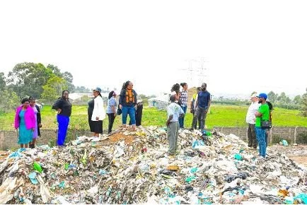
The first stop was the Kayole/Mdaki dumping ground, a vast area where waste has become both a source of livelihood and a daily health risk. Overcapacity, poisonous fumes from burning, and chemical leachate into nearby farms — eventually seeping into Lake Naivasha were among the challenges exposed.
But so were the solutions: composting through vermiculture and black soldier fly larvae for organic waste, sorting waste at the source, and converting dumpsites into material recovery facilities. These community-led innovations, often driven by women’s groups, demonstrated the power of transforming hazards into opportunities.
“We see waste differently now — as a resource,” shared one NAWOFE member, reflecting on the day’s learning.
The conversations on Day One set the tone for deeper reflection: how can community ingenuity, scientific knowledge, and partnership intersect to create safer, more sustainable settlements?
Day Two: Drawing Maps, Drawing Power
Day Two took place at KCC settlement, beginning with a stroll through its narrow roads — walking past ramshackle houses, hazard zones, and small but vital community assets.
Settlement orientation walk through KCC settlement
The centerpiece of the day was a participatory vulnerability mapping workshop. Residents divided into teams to map hazards, service delivery gaps, and social vulnerabilities. The result was a living map of KCC’s assets and challenges — a visual narrative of daily life in one of Naivasha’s most precarious spaces.
Community groups creating vulnerability maps during the workshop
More than mere paper, these maps rekindled the community’s determination to use them as tools for advocacy. They told stories no statistic could convey — where children face health risks, where women fetch water, and where flooding poses the greatest danger.
“This map is our voice; it has opened our eyes,” asserted one young participant, emphasizing how evidence can turn power into people’s hands.
Completed community vulnerability map displayed
Why It Matters
This was not a research tour. It was an exercise in bridging science and people’s lives — linking LSTM’s technical expertise with the planning potential of federations and residents’ lived knowledge. Together, they are establishing more sure-footed ground for locally driven, inclusive development.
The tour concluded with firm commitments to:
Use maps as advocacy tools to campaign for services and rights.
Strengthen women’s and young people’s leadership in community planning.
Enhance research–practice partnerships to address housing, WASH, and livelihoods.
Looking Ahead
Naivasha’s story is one of hardship, certainly — but also one of resilience and vision. From dumpsites to settlement maps, from women’s groups to youth voices, the LSTM visit was a reminder that sustainable urban futures must be co-created with those who live on the edge of vulnerability.
And in Naivasha, the edge is where hope happens.