Placing a slum’s identity in the hands of its slum dwellers!

A section of Mukuru kwa Reuben slum in Nairobi.
Communities and networks of the urban poor movement-Muungano wa Wanavijiji- have been collecting and collating data with the ultimate goal to build onto existing knowledge about their everyday lives in the slums.
Twenty years later, families in informal settlements in Nairobi and elsewhere in the country have come to internalise and appreciate the value of settlement profiling, enumeration and mapping. The city of Nairobi, capital of Kenya is one of the largest cities in Eastern Africa, with a population well over four million; unfortunately close to 60 per cent of this population reside in the informal settlements.
Joseph Kimani, a technical support officer with the federation’s support organisation SDI-Kenya recounts the urbanization spread in pre-independent Kenya, “With the hallmark of Kenya’s independence in 1963 and the abolition of colonial controls on migration to urban areas, the formerly segregated economic and political zone- Nairobi used to prefer ‘class rather than race’ with regards to city planning and service delivery. Rapid rural-urban migration was at its peak, fuelled by the industrial revolution which enhanced sustained pressure on existing available land.
With land being a factor of production continued to get scarce, and soon there was no more land to occupy and soon there was no official recognition or response to their existence in the city, the poor took to the occupation of ‘riparian reserves, undeveloped private and public lands, refilled quarries and garbage dumps, services reserves such as railway corridor zones, high voltage power lines and on road reserves’. In the early 1990s the urban poor especially those living in the city of Nairobi would come face to face with forced evictions. Land grabbers, beneficiaries of the corrupt patronage system by which ‘land was used to purchase political favours’ moved in to claim their ‘allocations’.”
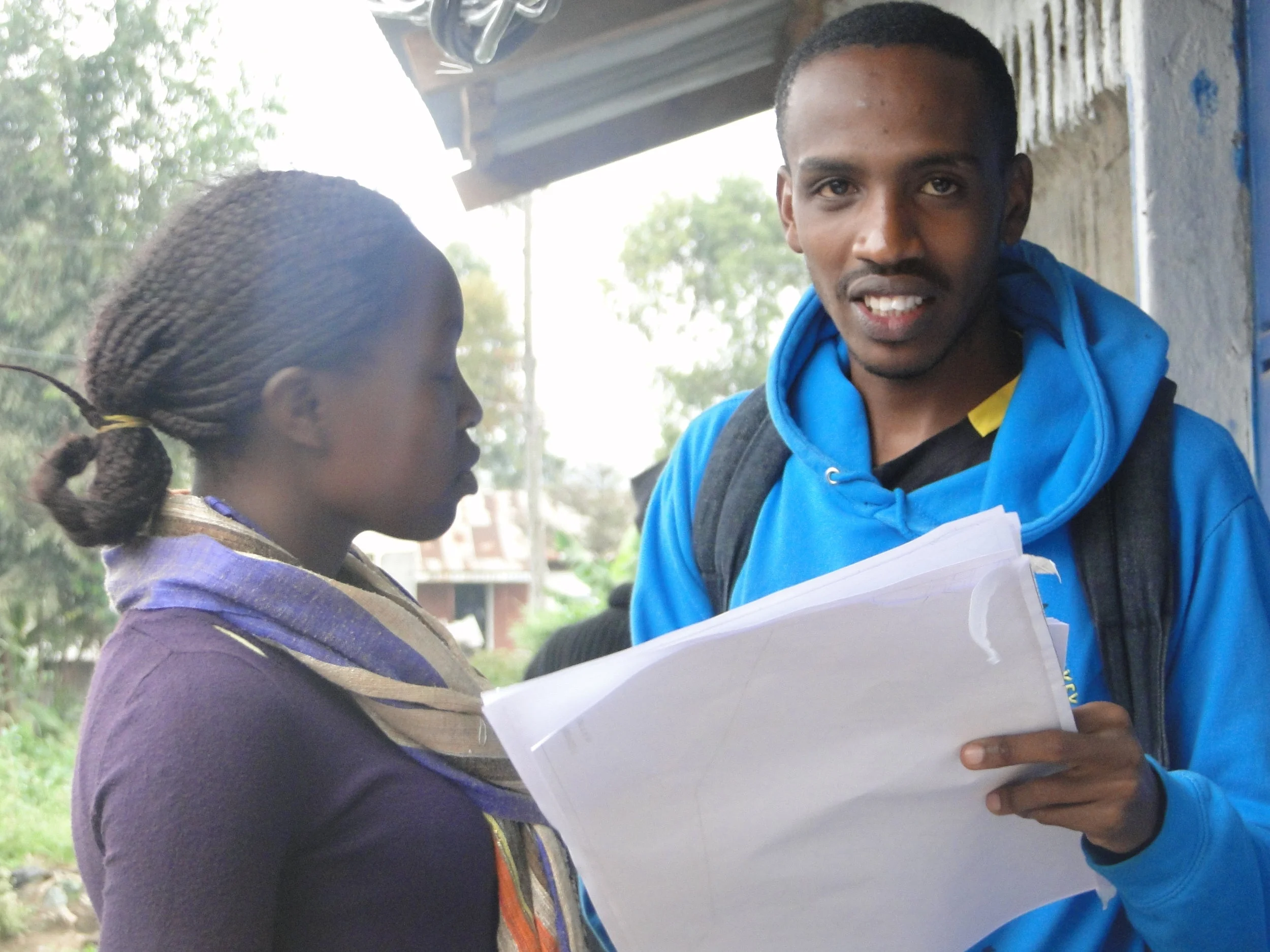
Kelvin supporting a recent settlement profiling in Mukuru Kwa Reuben.
Kevin Kinuthia gives a sneak preview of his life as a resident of Mukuru Kwa Reuben. “I was born in Mukuru Kwa Reuben slum, in a neighbourhood made up of factory workers, twenty six years ago. I was exactly twenty 23 years old, in 2013 when we helped stop a second attempt of an eminent eviction that changed the way Muungano wa Wanavijiji came to organise communities. The Cooperative Bank was in the process of selling a piece of land where we lived to offset a loan owed to them by a faceless developer. The bank recognised the strategic importance of the land, and started planning an auction of the land to recover its monies, not knowing the land was occupied by slum dwellers. Women and youth organised protests and wrote petitions, but initially we were failing on all fronts. We did not have any information about the settlement.
Luckily, other than picketing, Muungano wa Wanavijiji had moved to court to seek a court injunction for the courts to stop any demolitions of all informal settlements. The High court put a caveat on all looming evictions. Mukuru as currently situated lacks security of tenure and infrastructure, more so basic sanitation. A common bond was founded and we have come to realise that there is no need for another settlement to go through what we went through. We started thinking about ways to assist communities in similar situations, through building community awareness through advocacy in key Kenyan cities.”
Doris Moseti, a Women leader in Muungano wa Wananvijiji, explains the federation’s vantage point with regards to city wide settlement profiling:
“In 2013/2014 we started counting all the slums in six counties augmented in 17 towns. When we compared the numbers the state put forward in its 2009 census report, and that what we collected, we saw a large discrepancy: the state was always undercounting and downplaying the informal urban crisis.
We categorized the city by land ownership (private, state owned, county, etc) and identified the slums on those pockets of lands. For instance, as residents of Mukuru Kwa Reuben, first we needed to have the information before we start talking to the Nairobi County government. We have started organising communities around the data, and so begin creating settlement forums. For us, we have learnt that information and savings have real power in engaging with government.
The Know your city campaign aims to ensure that data collected by slum dwellers is suitable for urban planning.”
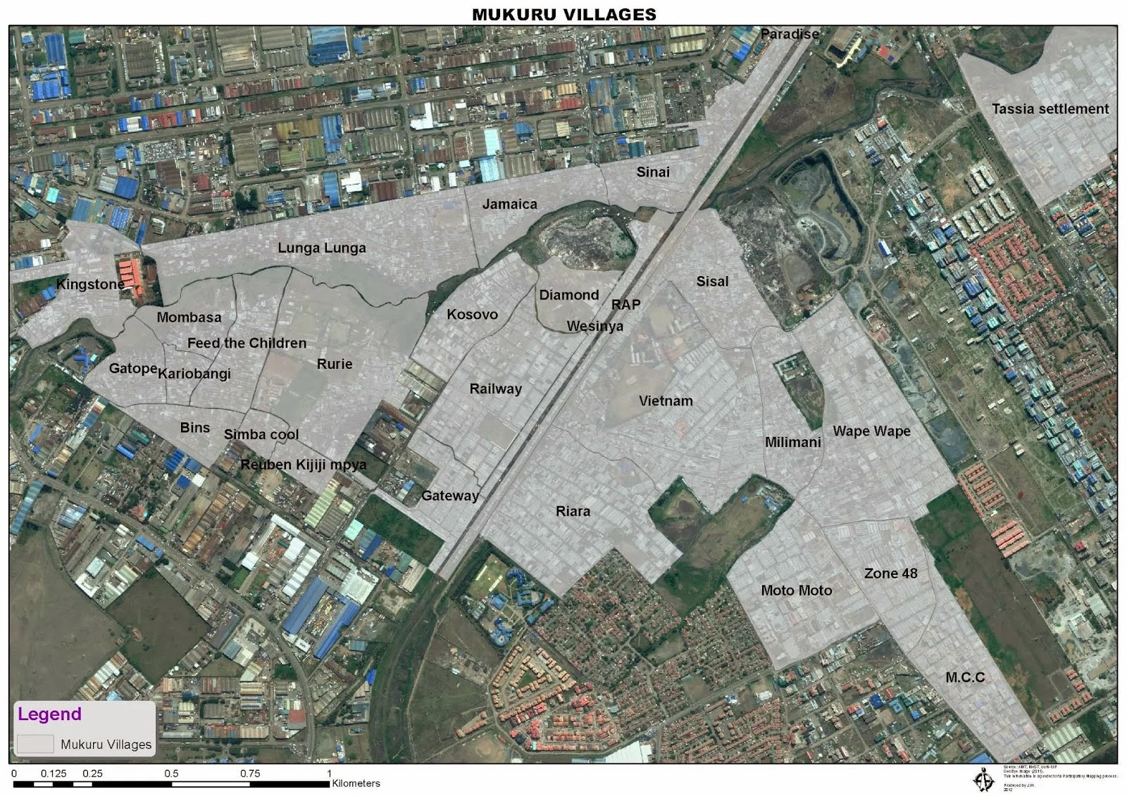
An overlayed cadastral map of villages in Mukuru Slums
Occupying 500 acres within the heart of the industrial district, Mukuru is home to over 137,000 residents. Mukuru is one of the largest informal settlements in Kenya divided into two main areas by a rail line – Mukuru Kwa Ruben to the west and Mukuru Kwa Njenga to the east. Each of these settlements includes several smaller villages.
The name ‘Mukuru’ literally means dumping site in Kiswahili. The neighborhood is the site of an old quarry where most of the stones used to build the surrounding factories were excavated. Parts of the area later became a dumping site for industrial as well as household waste. The history of this area can be traced back before independence when Ruben, a white settler and farmer used the area of Mukuru to keep livestock. Mukuru Kwa Ruben is named after this settler. Ruben employed a few Kenyan workers including Cucu Gatope, who built shelters on the land 1979 with her three daughters. The village Gatope within Mukuru kwa Ruben is named for this original settler. As the area grew, many individual villages were formed, each with their own particular history and name. Source: nairobistudio.blogspot.co.ke
Fast forward to post independent Kenya, Kilion Nyambuga, an urban planner with Muungano wa Wanavijiji, explains some of the practices in place that are aimed at addressing the challenge of security of tenure in the city, and proposing ways of pre-colonial planning practices that segregated the planning of informal settlements:
“The federation, an affiliate Slum Dwellers International (SDI) employs three simple SDI data-collection methods, that is: settlement profiles, household surveys, and mapping. These three processes are led and managed by the communities themselves after undergoing a mandatory technical data training, which on average takes two days, after cognitively identifying the settlement boundaries.
The value of the data they collect is well recognised and understood within the settlement. The Mukuru slums data collection is reflected in the numerous working partnerships with the Nairobi City County government and agreements with Muungano’s networks across other cities such as Kiambu, Mombasa, Kisumu and Nakuru have formed with local governments, international bilateral agencies.”
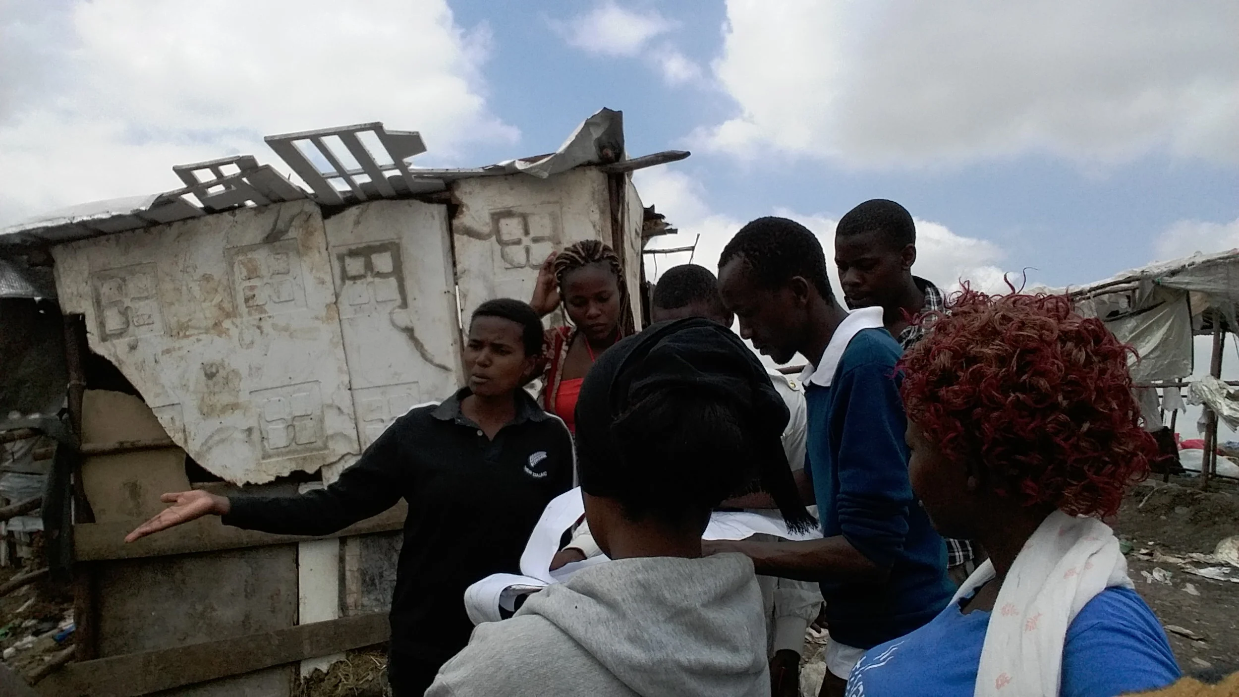
The Mukuru Kwa Reuben profiling team, maps out structures and services in the settlement.
Muungano wa Wanavijiji and its city/county networks use data collection to produce social and political information for themselves that aims to symbiotically link their communities together and build relations with their local county authorities and other government agencies. With daily savings and peer-learning exchanges, urban poor communities mobilise and organise to effect real change in their settlements and everyday social lives.
The data produced as is the case of Mukuru becomes the basis of building and sustaining social and political relations with the Nairobi City County government. The initiative runs under the auspices of the Access to Justice and Basic services in Informal settlements. The project has seen the leveraging of goodwill form city authorities, more so on the proposal to create city housing fund as a substantive way to improve the lives of thousands of slum dwellers in Kenya.
The access to justice and basic services in Nairobi informal settlements project was implemented by cluster partner organizations: Akiba Mashinani Trust (urban poor fund), Katiba Institute (legal) Strathmore Business School (finance and economics), Nairobi University (planning), University of California Berkeley, SDI-Kenya (community organizing and settlement profiling), and Muungano wa Wanavijiji (urban poor movement). Broadly, the project aimed to activate and engage the urban poor to work closely with city governments in activities that will improve security of tenure for poor urban communities. The program is funded by the International Development and Research Centre (IDRC).
“The settlement based profiles are collected by means of household-surveys, structure and services tallying tools and community-led mapping. This data captures and realistically portrays the informal settlement dwellers everyday lives and living conditions and visually communicates the scale and extent of informality and service deprivation in the spaces they occupy in the city,” says Vane Cathy Kerubo a resident of Landimawe location in Mukuru Kayaba.
Kerubo is one of the federation’s data team members from Mukuru Kayaba who joined hands with their Mukuru Kwa Reuben to profile their settlement.
Kerubo goes on to shade more light as to what are some of the benefits of settlement profiles:
“There are multiple benefits from community-led data collection. The three levels of data collection- settlement profiles, household level enumerations and mapping of structures and services serve to mobilise communities and is crucial for the people of Mukuru Kwa Reuben to know their settlement inside out, from the population, existing services and resources available in the settlement, to inform on planning. The data also serves as an advocacy tool and for opening doors to initiate dialogue with city authorities.”
The completion of the survey questionnaire used in profiling is key for community members, since it gives the residents an opportunity to actively debate the information gathered. Settlement stakeholders from settlement and community leaders, regular residents, community based organisations and interest groups like women’s groups and youth groups, are invited to attend the focused group discussions.
Upon completion of the profiling, the federation returns all data collected to the community at a follow-up meeting. The data returned include a digitised copy of the survey questionnaire, a copy of the boundary and services map produced, as well as a basic first report on the distribution of basic services and the development needs of the settlement as prioritised by the community.
During the follow-up meetings the community will have the opportunity to verify the data, reflect on it and begin the process of collective development planning based on their information. With a now-concrete understanding of the location and extent of land and access to basic services, the community as a collective may engage in informed planning for their settlement.
The profiles build a sense of settlement ownership as communities identify with their borders, enhance advocacy for change and lastly begin to inform community planning strategies for housing and infrastructural development.
GIS maps of the boundary and services maps of these settlements on the other hand support Muungano’s city settlement profiles. The profiling tools – survey, tallying and mapping forms – remain closely connected to the settlement maps that do not allow any margin of error but enhance accuracy.