Addressing Land needs of Kijipwa settlement scheme, Kilifi County
The history of the coastal area is unique and this has implications on then different ownership categories in the province. Historically, the 10 mile coastal strip was once a possession of the sultan of Zanzibar and was leased to the British when the East African Protectorate was established. It was bought by the British and became part of independent Kenya in 1963.The 10 miles coastal strip became part of un-alienated government land under the government lands Act.
According to official government statistics, about 70% of un-alienated government land is found in the coast Province. This is land which can be allocated to private individuals, and entities at the discretion of the commissioner of lands. Other categories of land in the province include, Trust land, settlement scheme sand land which is privately owned. When communities live on government land, they are classified as squatters, whether or not they have lived there since pre- independence days and can show that it is their ancestral land. When such land is allocated to individuals, the squatters are evicted without any compensation. The land, on which the project site lies, is classified as government property.
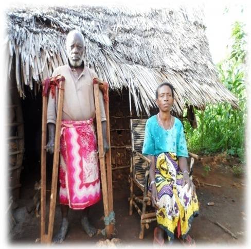
BENEFICIARIES of Kijipwa settlement scheme in Kilifi have had land issues that the Government needs to solve having ignored their plight for the last two decades. The residents claim the government failed to issue them land certificates, as reinstated through the settlement scheme initiated in 1982 by the government, to settle the squatters in Kilifi during a public forum organized by Muslims for Human rights (MUHURI).
Upon subdivision of the land by the government several big shots unfairly benefited from the land allocations. Some of the personalities who had benefited from the allocations include;
Plot
Name
Position(Then)
96
James Peter Kiyungu
Ministry of Lands
277
Boniface Mghanga
Office of the President
53
Steven Timothy Wakisha
PC Nairobi
48
Mada Gopal Saini
Legal Officer, Ardhi House
43
Toshiba Toshimbai Patel
Legal Officer, Ardhi House
41
John Thiong’o Mwaura
Physical Planner
43
Anderson Kariuki Chomba
Physical Planner
Over 3,000 families risk being landless and homeless if the matter is not addressed with the seriousness it deserves.
Post-Independence settlement schemes in
Kilifi and Malindi Districts
Starting
Size
No.
Plot
date
(ha)
plots
size (ha)
Diani
1978
728
446
2
Golini
1985
290
102
2
Mbuguni
1978
2,400
787
2.4
S^abharwal
1968
120
20
4.8
Tembo Springs
1968
202
26
4.8
Ukunda
1968
607
123
4.8
Kijipwa
1982
350
350
1
Magarini
1978
60,000
4,000
6.0/12.0
Mtondia
1962
3,000
235
4.8
Mtwapa
1969
3,986
607
4.8
Ngerenyi
1968
5,236
950
4.8
Tezo/Roka
1962
6,500
1,357
4.8
Vipingo
1974
1,052
260
4
Tabulated Kijipwa Settlement Demographics
Plot
No. Of Families
Population
Plot Size
Plot 96
109
623
120 acres
Plot 9
73
491
210 acres
Kwa George
26
153
20 acres
Plot 35
31
209
25 acres
Plot 41
34
143
25 acres
Plot 48
64
305
48 acres
Plot 43
83
297
48 acres
Some of the individuals who benefited from the land allocation in Kijipwa Settlements include;
Plot Name
Name
Plot Size in acres
35
Anderson Kariuki Chomba
7.76
41
John Thiong’o Mwaura
9.70
43
Thakorbhai Patel
19.28
48
Mada Gopal Sauni
19.8
53
Steven Mwakisha
20
82
Cemetry(Mama Masai)
2.237
96
James Mbandi Kinyangu
37.0
The settlement has a total of 355 plots measuring a total of 600 ha.
Through a participatory engagement that saw the process of mapping and enumerating the entire Kijipwa settlement scheme which had the support of Ujamaa center, Muungano support Trust (MuST) and Muungano wa Wanavijiji entailed a series of steps through combined effort of the stakeholders. The process realized collaborated efforts of the community youths, who after the training managed to achieve the presumed task of generating an all inclusive community data and information.
The initial strategy was to sensitize the community on the expected mapping and enumeration process (held on 20th June 2012) the sensitization forum was held in Mgandini (under mgande tree).The forum was in held in collaboration with Muungano Wa wanavijiji, Akiba Mashinani Trust and Muslims for Human rights (MUHURI) and the community leadership representation being, the area Chief and Councilor.
Being a community process, the residents needed to have a sense of ownership. The forum was to bring the entire settlement to read from the same script, which would enable them develop a workable formula to address the community’s plight on land ownership and secure tenure.
Akiba Mashinani Trust team, enlightened the community on the concept of savings for the future development, where they could save as little as ten shillings in a day and use their compounded savings to secure development loans, for house construction and establishing sources of livelihoods.
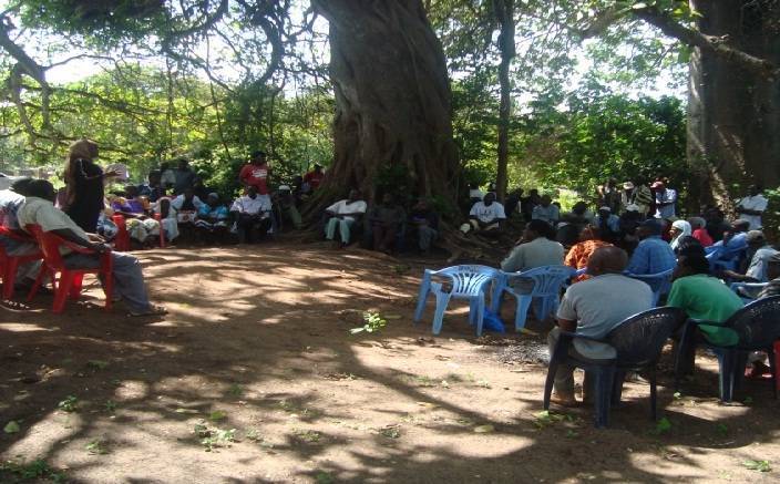
Munira, Ujamaa CM addressing the community members during the meeting
Owing to the emotive nature of land perspectives in the Coastal town of Kilifi, Legal and Land experts were called in to give their views and possible scenarios to the land tussles. A conflict resolution committee, composed of elders was then set up to handle any pedigree of conflict that would arise during the mapping and enumeration process. The forum was also used as a platform to nominate persons to spearhead the numbering and enumeration exercise.
Training and pretesting
MuST team was tasked with the responsibility of administering training to the community enumerators on enumeration processes and the tools involved. Community maps and settlement data are a community’s lifeline in brokering engagement and understanding between communities and service providers and by extension the government. Here communities can advocate for; roads, water and sanitation services, Health, electricity and so on.

David Mathenge (in green T-shirt) MuST official facilitates community training forum.
Household Numbering
Community enumerators were invited to develop code numbers, to match the settlements to be enumerated and mapped i.e. KJS (Kijipwa settlement). The initials were preceded by the plot number and finally the house number. Hence the code would look like; KJS/96/001.
Pretesting
The enumerators were then sent to the filed to fill one enumeration form each and returned for crosschecking and subsequent correction thus setting the enumerators ready for the work the following day. The enumerators were divided into groups according to the plots they were coming from because it was believed they understood the area more.
Challenges
- As the training was going on, construction of strictures were also on the go just to be part of the enumeration process despite the process targeting families and the constructions were not households leading to attempt to bribe a team member to allow numbering of the structure which was not a household.
- Even after setting rules that exercise, some of the newly constructed houses were numbered contrary to the earlier made agreement being the influence of some of the elders who were instrumental and was also working closely with the enumerators because of the influence of these house owners
- There was a lot of expectation from the community memberswith the thought that the process was going to settled their land problem almost immediately that could be reflected when some were asking sasa lini tutapata cheti ya ardhi (now when do we get the land titles) and the other who were on the road reserves were kin to know if they will be evicted being the some of the community members were not even happy with the fact that they will be enumerated.


From left a family living in Mombasa constructs a house to be enumerated and the right a local who is said to have been living under a tree is helped construct the structure so that he too could be enumerated
- Lack of unity of purpose where different groups were emerging being wenyeji verses Wa bara (the locals verses the people from up country), the people who were allocated plots verses the people living on the road reserves. This thus was more confusing especially to the people who were on road reserve who might have thought of being left out of the process.
- Owing to the intense desire to sort out land issues, unclear boundaries in some cases led to confrontation when some community members thought that the process was to legalize their land ownership and boundaries at some point led to neighbors confronting each other to correct the boundaries just before the process so that they could be counted with their rightful belonging in terms of land size.
- Lack of cooperation among some community member who refused to give information while others dint allow their doors to be numbered saying the paint was going to leave a bad mark at their doors